


GPS , Google Maps and Taxi Drivers
Wonderful devices, but.........
Modern GPS and Google Map service makes finding places easier everyday. Having used various models for many years, there accuracy is amazing, and even the smallest roads are marked. Butt..........
GPS Coordinates are listed below, but check our warnings first.
Problem #1 Bangkok to the Sam Kok, Prathum Thani area.
None of the software (or Taxi Drivers) like to use the Outer Ring Road because of the extra distance. From center of Bangkok, GPS, Google & Taxi will route you up the 2nd stage Expressway to expressway 31 (Udon Ratthaya Hwy or Bang Pa In- Pak Kret Expressway) The same route we recommend, but instead of continuing North to Western Outer Ring Road, It will have you exit at HWY 346 Bang Phun - Rangsit
 The
distance is saved is considerable, and time is about the same.
Cheaper to go this way in a taxi running on a Meter.
The
distance is saved is considerable, and time is about the same.
Cheaper to go this way in a taxi running on a Meter.
Follow 346 to Prathum Thani, and after you cross the Chao Phraya river you will come to HWY 3111. Turn Right in the direction of Sam Kok - Sena.
In general, for this you can trust the GPS. All will get you to the Interchange 3111 and Western Outer Ring Road.
Problem # 2, Not all streets are marked on all maps.
Google Maps, Nokia Phones and some GPS devices are missing a very critical street to easily get to TE. If you blindly follow your GPS you will end up in the rice fields.
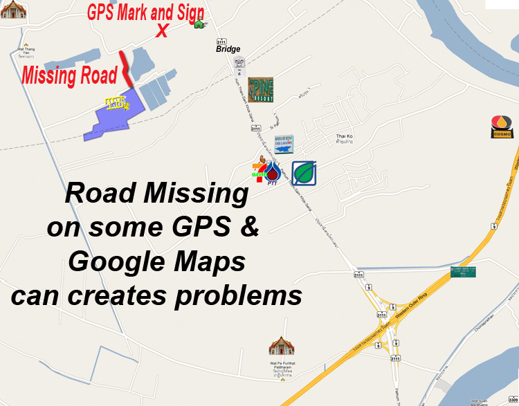
To solve this problem, we recommend you enter the coordinates for the GPS Mark and Sign shown above. This will get you to Soi Wat Thong Yaow, and you can follow the TE Wake N Ski Signs.
GPS Mark and Sign
Latitude 14° 7'24.62"N
Longitude 100°29'38.43"E
Download TE SIGN 5.kmz for Google Earth
TE Wake N Ski
Latitude 14° 6'51.67"N
Longitude 100°29'13.39"E
Download TE Wake N SKi.kmz for Google Earth
Good Luck!!!